This page provides an overview of the data from the Valentin-3D project in which the Memorial Submarine Bunker Valentin was digitized. The data is released under the Creative Commons Attribution-NonCommercial (CC BY-NC) license, i.e., you use the data for own non-commercial work and you must acknowledge its origins; please do so with a link to the project webpage “http://valentin3d.de” and by citing the following publication that gives an overview of the project:
Andreas Birk, Frederike Buda, Heiko Bülow, Arturo Gomez Chavez, Christian A. Müller and Julia Timpe. Digitizing a Gigantic Nazi Construction: 3D-Mapping of Bunker Valentin in Bremen. Writing the Digital History of Nazi Germany, De Gruyter, https://doi.org/10.1515/9783110714692-006, 2022
If you plan a use-case in a commercial context or if you are simply not sure whether the intended use is in compliance with the CC BY-NC license, please contact Prof. Andreas Birk. Please take the tragic history of the bunker into account when using the data, i.e., please do not use it for impious or irreverent work. Note that most of the data-sets are very large, i.e., their download can take a long time even with fast internet connections.
The data is organized into multiple folders under https://robotics.constructor.university/DATA/Valentin3D/. Some information on the data in the different folders is given below.
UAV Data
Videos from an Unmanned Aerial Vehicle (UAV) are provided in the subfolders in UAV-videos. The vehicle used for the recording is a Phantom 4 Pro+ V2.0. In addition to videos of the outside of the bunker, there are recordings from the inside of elevated areas that are not accessible anymore and that can not be captured with the laser-scans inside of the bunker from the ground. Some image data-sets generated from the videos are located in UAV-photos. They can be used for the generation of 3D models with photogrammetry without the need to process the videos.
Laser-Scans
Laser Range Finder (LRF) data from the inside and at a few openings of the bunker are provided in laserscans. The scans are recorded with a FARO Focus3D 120, which provides range and color information, i.e., the point-clouds are RGBD. In addition to the raw FARO data-format, the scans are provided in multiple open formats including LAS, XYZ and XYZRGB. Also, panoramic images are given for all scans that allow to get an impression of the data contained therein, respectively to be used for research on monocular depth estimation. A rough overview of where the scans are taken is given in this scan-overview-diagram.
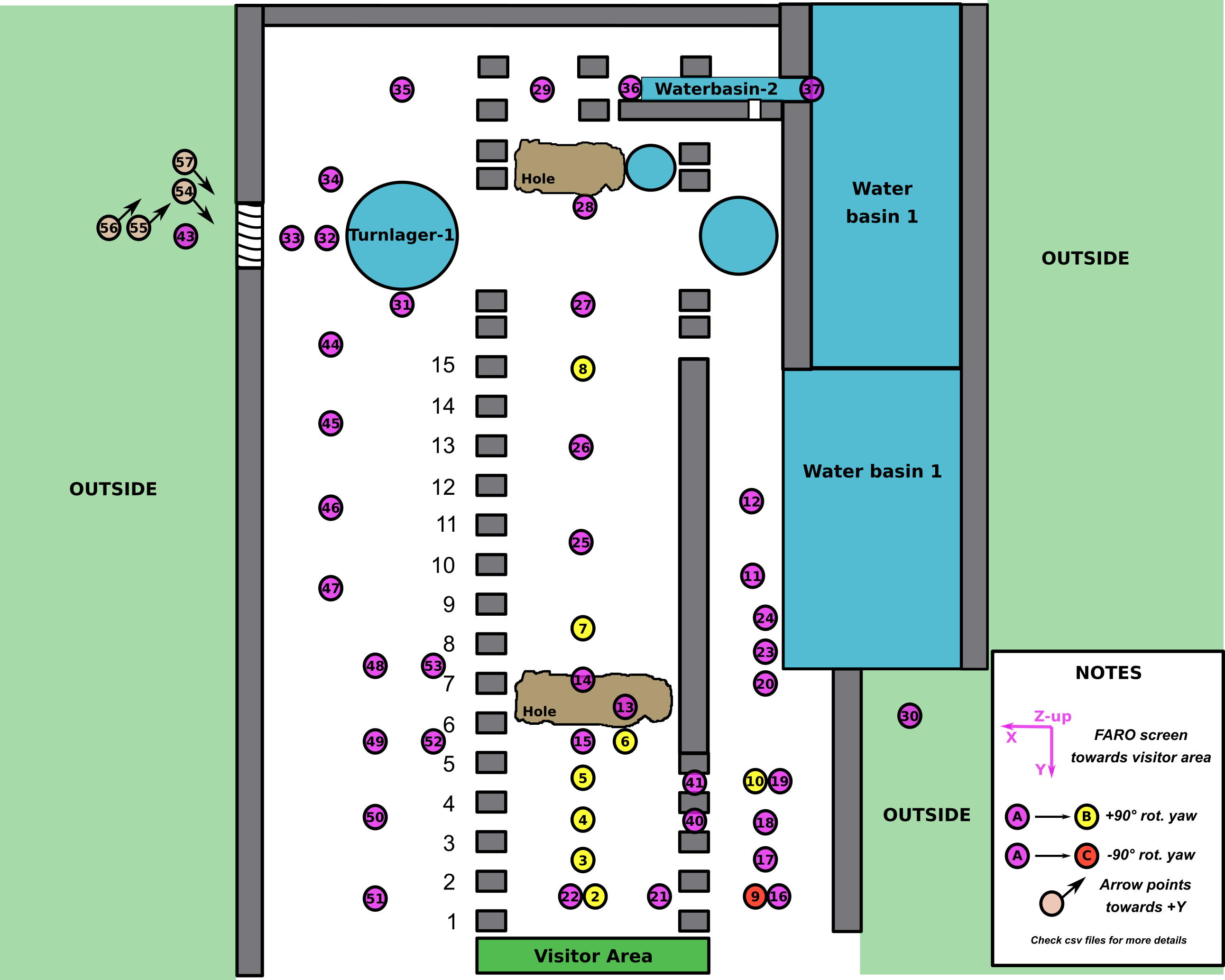
Underwater Data
The bunker has multiple flooded areas, e.g., a large basin planned for the release of the sub-marines into the nearby river Weser as well as extensive flooded basement areas. The underwater data was collected with a VideoRay Academic Version and a BlueROV 2, both with substantial modifications and add-on’s, e.g., in form of additional sensor payloads. Videos recorded during the dives are located in UUV-videos. Sonar data can be found in UUV-sonar.
Construction Plans
For the planning of the data acquisition and for historical research, construction plans of the bunker were digitized. The data can be found in plans. Most of the plans are very large and fragile, some are even already partially broken. Hence, simple photographs were taken in an initial review at the bunker and more high-quality photos were taken of selected plans with a special set-up using a gantry and a protective plexiglas-cover in the robotics lab at Constructor University. Furthermore, there are plans that give some insights into the planned production of the submarines.
Photos
Some photos from the bunker Valentin are provided in photos. The pictures provide a few impressions of what the bunker looks like and how the conditions in the ruin are.
Models
A collection of models generated from the data is located in models. Simple web-based visualizations that provide a first overview can be found under the following links
- bird-eye exterior (from UAV & photogrammetry)
- ruins interior (1st overview from LRF)
- ruins interior (more detailed overview from LRF)
- interior, 3x top left support (from UAV & photogrammetry): DJI_0025 , DJI_0026 , DJI_0027
- interior, 1x top right support (from UAV & photogrammetry): DJI_0021